Paleogeography
A geographic map of the world as it appeared during Devonian time would show a virtually unrecognizable planet.
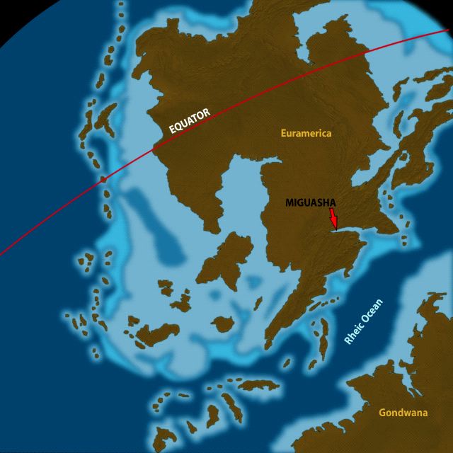
 (52 kb) Most landmasses had joined together to form two large continents, and one of these, called Euramerica by geologists, straddled the equator and was spanned from north to south by a mountain chain in the final stages of formation. Euramerica and its impressive mountain chain were created when two landmasses, Laurentia and Baltica, collided. One of the many river systems draining these mountains flowed into the large Miguasha estuary.
The other large landmass, called Gondwana, occupied a good portion of the southern hemisphere and even covered the South Pole. It lay quite near the southern end of Euramerica, and the two finally collided in Upper Devonian time, closing the Rheic Ocean between them.
By 300 million years ago at the end of the Carboniferous Period, Euramerica and Gondwana had fused together to form a single supercontinent called Pangea. This supercontinent would later split apart and form the Atlantic Ocean. The event divided Euramerica’s mountain chain, and the two halves drifted apart, bordering either side of the expanding Atlantic. Today, they are known as the Appalachian Mountains in North America, where they extend from Alabama to the island of Newfoundland, and the Caledonide Mountains on the other side of the Atlantic, where they are found in the British Isles, the Scottish Highlands, Norway, Sweden, and along the eastern margin of Greenland. On the western edge of the African continent, the Mauritanides were also part of this mountain building event.
The Appalachian Mountains were built up during the Devonian Period, when their peaks would have been much taller and sharper than they are today. Millions of years later, erosion has reduced them to rounded hills and valleys in the heart of the Gaspé, creating the impression of an undulating verdant sea.

 (52 kb) Most landmasses had joined together to form two large continents, and one of these, called Euramerica by geologists, straddled the equator and was spanned from north to south by a mountain chain in the final stages of formation. Euramerica and its impressive mountain chain were created when two landmasses, Laurentia and Baltica, collided. One of the many river systems draining these mountains flowed into the large Miguasha estuary.
 The other large landmass, called Gondwana, occupied a good portion of the southern hemisphere and even covered the South Pole. It lay quite near the southern end of Euramerica, and the two finally collided in Upper Devonian time, closing the Rheic Ocean between them.
By 300 million years ago at the end of the Carboniferous Period, Euramerica and Gondwana had fused together to form a single supercontinent called Pangea. This supercontinent would later split apart and form the Atlantic Ocean. The event divided Euramerica’s mountain chain, and the two halves drifted apart, bordering either side of the expanding Atlantic. Today, they are known as the Appalachian Mountains in North America, where they extend from Alabama to the island of Newfoundland, and the Caledonide Mountains on the other side of the Atlantic, where they are found in the British Isles, the Scottish Highlands, Norway, Sweden, and along the eastern margin of Greenland. On the western edge of the African continent, the Mauritanides were also part of this mountain building event.
The Appalachian Mountains were built up during the Devonian Period, when their peaks would have been much taller and sharper than they are today. Millions of years later, erosion has reduced them to rounded hills and valleys in the heart of the Gaspé, creating the impression of an undulating verdant sea.
Site map | Feedback | Links | Sources | Credits
Paleogeography
<< Tectonic context | Climate >>

Title: Location of the ancient estuary of Miguasha
Author: François Bienvenue
Sources: Ron Blakey (http://jan.ucc.nau.edu/~rcb7)
Year: 2007
Description:
During the Upper Devonian, the source of the ancient estuary originated in the young Appalachian Mountains newly formed at the southeastern boundaries of the continent of Euramerica. The position of the ancient continental landmasses is by Ron Blakey (http://jan.ucc.nau.edu/~rcb7)


